Convert square miles to acres and discover why the number 640 shaped the layout of farms, roads and property lines across much of the United States. One square mile always equals exactly 640 acres — a relationship with a specific historical origin, explored below.
Square Mile to Acre Conversion Formula
One square mile contains exactly 640 acres. This relationship follows from one square mile containing 27,878,400 square feet and one acre containing 43,560 square feet.
The conversion formula is:
1 mi² = 640 ac
Or simply:
Acres = Square miles × 640
This conversion uses international-foot-based area values: 1 mi² = 2,589,988.110336 m² and 1 ac = 4,046.8564224 m².
These conversion values and the exact relationship 1 mi² = 640 ac are documented in the NIST revised unit conversion factors and the NIST Guide to the SI conversion tables .
Common Square mile to Acre Conversions
- 1 mi² = 640 ac
- 10 mi² = 6,400 ac
- 100 mi² = 64,000 ac
- 1,000 mi² = 640,000 ac
- 10,000 mi² = 6,400,000 ac
Square Miles to Acres: Reading the Grid Across the American Landscape
Square miles are useful for describing forests, parks, ranches and districts, but individual parcels are often recorded in acres. Converting between the units allows a large mapped area to be compared with farms, development sites and legal property descriptions.
The conversion is exact:
1 square mile = 640 acres
To convert any area from square miles to acres, multiply by 640:
Acres = square miles × 640
How One Square Mile Became a Survey Section
Beginning in the early history of the United States, federal surveyors used a rectangular system to identify and divide much of the public domain. A principal meridian provided a north–south reference, while a base line provided an east–west reference. Surveyed land could then be described by township, range and section.
The ideal survey township measured six miles from north to south and six miles from east to west:
6 miles × 6 miles = 36 square miles
Converting that nominal area into acres gives:
36 mi² × 640 acres per mi² = 23,040 acres
Each township was normally divided into 36 numbered sections. An ideal section measured one mile on each side and contained 640 acres. The sections were numbered in a serpentine (boustrophedon) pattern beginning in the northeastern corner of the township: numbering runs west across the top row to Section 6, drops down a row and runs east back to Section 12, and continues zigzagging back and forth until it ends at Section 36 in the southeastern corner.
The Bureau of Land Management's guide to legal land descriptions explains how townships, ranges, sections and smaller subdivisions are used to identify land.
From a Section to an Individual Property
A section could be divided repeatedly into halves and quarters. Under the ideal grid, every division also produced a familiar acreage:
- Half-section: 0.5 square mile or 320 acres
- Quarter-section: 0.25 square mile or 160 acres
- Half of a quarter-section: 0.125 square mile or 80 acres
- Quarter-quarter section: 0.0625 square mile or 40 acres
These subdivisions, known as aliquot parts, allowed a parcel to be identified by its position inside a larger section. A description such as the northeast quarter of a section identifies a particular part of the grid rather than relying only on a street address.
Common Square-Mile Areas Expressed in Acres
| Square miles | Acres | Survey-grid comparison |
|---|---|---|
| 0.0625 mi² | 40 acres | Quarter-quarter section |
| 0.125 mi² | 80 acres | Half of a quarter-section |
| 0.25 mi² | 160 acres | Quarter-section |
| 0.5 mi² | 320 acres | Half-section |
| 1 mi² | 640 acres | Full section |
| 6 mi² | 3,840 acres | Six ideal sections |
| 10 mi² | 6,400 acres | Large park or ranch area |
| 36 mi² | 23,040 acres | Ideal survey township |
Why the Grid Is Visible From Above
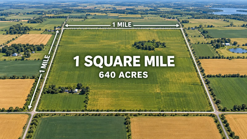
Across many parts of the Midwest and western United States, aerial photographs show long straight roads and rectangular fields. Some of these features follow section lines or smaller divisions inherited from the public-land survey grid.
The pattern influenced more than property records. Survey boundaries could shape the placement of roads, fences, farms and drainage systems. As neighbouring parcels were divided or combined, later landscapes often retained traces of the original rectangular structure.
The pattern is not universal. The PLSS was not used in the same way across the original thirteen states, Texas and certain other areas governed by older or separate land-description systems.
Why Real Sections Can Differ From 640 Acres
A flat sheet of squares cannot be extended indefinitely across a curved planet without adjustment. Survey lines running toward true north gradually approach one another because meridians converge. Measurement limitations, waterways, earlier boundaries and other physical conditions also affected the layout.
Surveyors used standard parallels, guide meridians, correction lines and fractional lots to manage these differences. Under the general survey plan, an excess or deficiency was commonly placed along the northern and western sides of a township rather than distributed evenly among every section — specifically the top row of sections and the westernmost column, with the northwest corner section typically bearing the largest adjustment of all, since it sits where both correction edges meet.
The Bureau of Land Management describes townships and sections as nominally six miles square and one mile square in its Specifications for Descriptions of Land . That wording is important: the grid establishes a legal survey framework, but it does not guarantee that every recorded section contains precisely 640 acres.
An Exact Conversion and a Surveyed Acreage Answer Different Questions
If an area is stated as exactly 2.5 square miles, its mathematical conversion is straightforward:
2.5 mi² × 640 = 1,600 acres
A historic property described as two and a half survey sections may not contain exactly 1,600 surveyed acres, however, because one or more sections could be fractional. For legal or purchasing decisions, the official plat, deed and surveyed acreage should be consulted.
The converter answers the unit question: how many acres represent a stated number of square miles. A land survey answers a different question: how much area lies inside the property's legally established boundaries.